


History of Chapelfields
This early map of Chapelfields around 1846 shows the intentions of the developers. The map is entitled:-
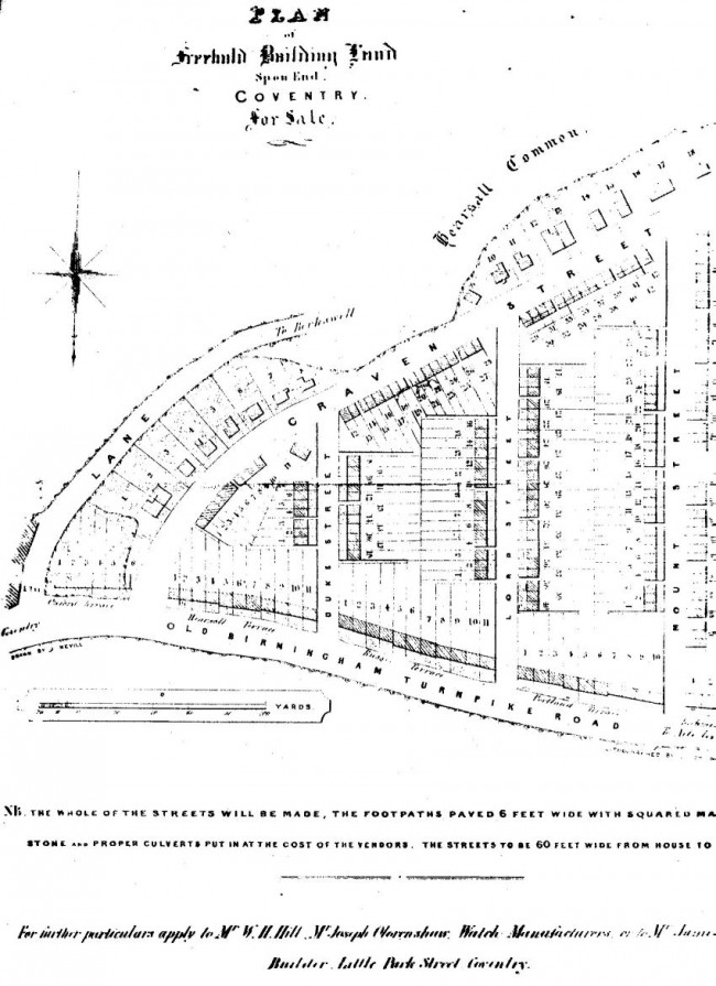
Plan of Freehold building land : Spon End : Coventry : For Sale
NB The whole of the streets will be made, the footpaths paved 6 feet wide with square Marston stone and proper culverts put in at the cost of the vendors. The street will be 60 feet wide from house to house.
For further particulars apply to Mr.W.H.Hill, Mr.Joseph Clarenshaw: Watch Manufacturers or apply to Mr.James Marrell Butcher. Little Park Street. Coventry.
These were some of Coventry’s earliest developers.
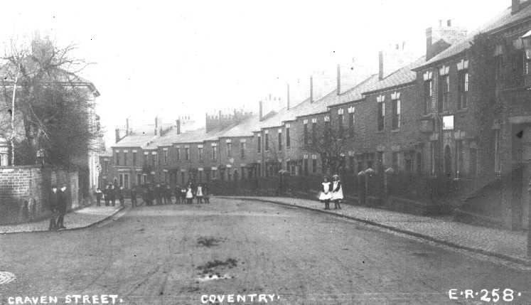
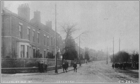
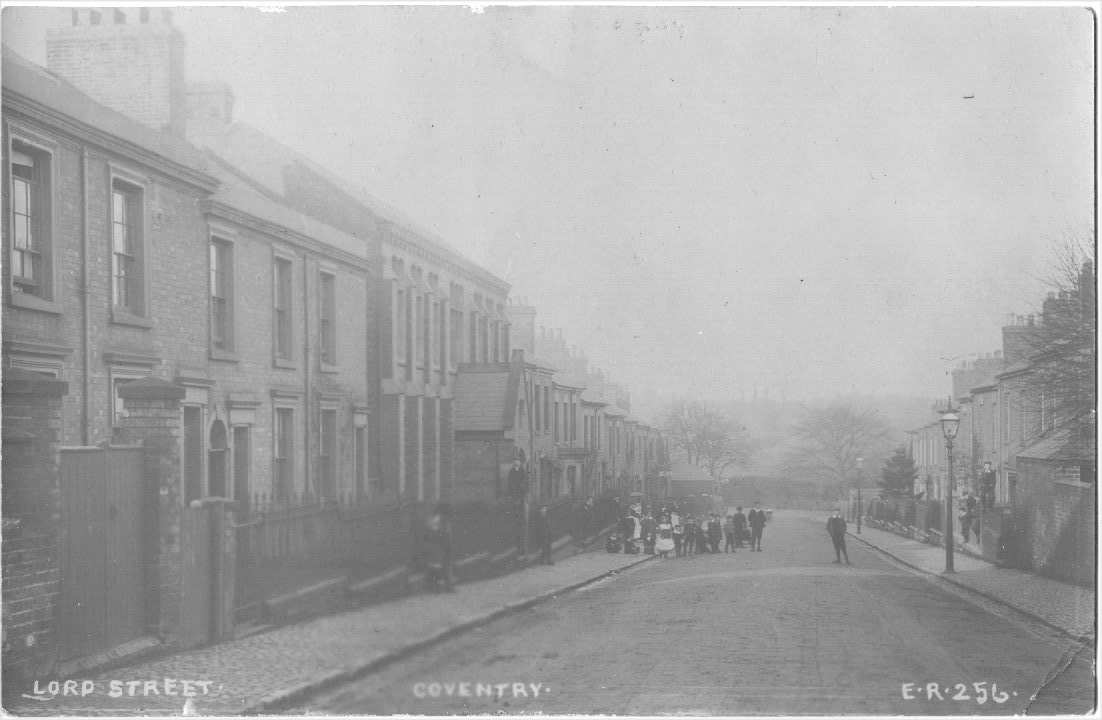
At that time, around 1860, this was a fine specification. The plan was for 17 houses in Duke Street, 40 in Lord Street and around 50 in Mount Street, four terraces of around ten houses each in the Allesley Old Road and 40 small houses on the north side of Craven Street. The south side of Craven Street was to have just 19 much larger houses.
In the event the large houses were built on corner plots and the whole of Craven Street was built with relatively small houses. Many of the corner plots had very large houses on them together with substantial workshops attached at the rear. These were generally known as “Master’s houses”. All of the houses had “Top Shops” of varying sizes and all were devoted to the watch making trade.
The whole area was devoted to the trade just as the slightly earlier development of Hillfields had been devoted to weaving. The trade thrived until around 1890 when cheap mass produced watches became available from Switzerland and the USA. Watch making declined slowly and finally ceased around 1930. There were hundreds of workshops, and the tradition of working from home persisted, and many of the workshops and houses were used for many other industrial purposes.
Although the streets bear terraced houses, every house was built to the specification of its buyer and most of the houses are different from each other. Some have more upstairs windows than others and are wider. The designs of the Top Shops were all different and most houses had two storeys at the front and three at the rear, the third floor housing the maid. Almost every house had an individually designed doorway and porch. All the windows were of sash construction and many had sash shutters that dropped into the window sills. Many houses had cellars.
Most houses had a small front garden with a large stone slab defining the path at the street with a wrought iron post let into with and held by a cast lead stop. The post had a support stay and onto it was mounted a wrought iron gate. A low brick wall was topped by large dressed stone slabs with a wrought iron fence let into it. The whole produced a fine Victorian street line offset with cast iron lamp posts along the curb line.
Some of the internal decorations were fine with plaster cornices and ceiling roses. Every house had an outside toilet and wash house. Those people who had left the Coventry “Courts” to move here had achieved a fine change in their circumstances indeed.
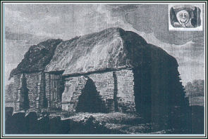
When Hugh Kevilock, Earl of Chester, had returned from a crusade around 1100 he built a hospice and a chapel to house one of his knights who had contracted leprosy. The leper hospital was moved to Alcester in the 17th century but the chapel survived until it was demolished to build the Chapelfields estate, the ‘chapel in the fields’ being the source of the name. The chapel had been called St. Mary Magdalenwhich name still exists in the ‘Blue Roofed Church’ at the top of Hearsall Lane.
There Is a photo of the Leper Chapel, courtesy of CCC planning conservation office, in the gallery below.
The 1851 census gives interesting information. Despite being some of the more wealthy artisans in the city, there were few men over 55 and few women over 65. There were many widows but few widowers. Almost every house had a 16 year old maid and an average of only around three children. This was quite a low figure for the time when six or more children were common.
As late as 1960 the area housed a wood yard, two small engineering factories, an ironmongers, a photographer, steam bakery, the factory in Lord Street, a chip shop, greengrocer, post office, grocer and a tailor.
There are also seven of the best pubs in Coventry, five in Craven Street and one in Lord Street and one in the Allesley Old Road. The Sun Dial in Lord Street closed around 1930 and the Board Vaults in Craven Street disappeared long before that. Because of the pubs, the area retains much night life but without the horrors that accompany much modern night life. The potential trouble makers take a taxi into the nearby city centre before they get tanked up.
The area still attracts a number of small businesses and is attractive because it has good access roads, reasonable amounts of daytime parking, relatively cheap business accommodation and around nine active bus routes. All-in-all this is a thriving and friendly community and an excellent place to live and work.
In 2008 the street lines exist largely unchanged and most of the building lines also remain. The small area has managed to retain its Victorian characteristics despite substantial upgrading of many properties through an Assisted Area status in the 1980’s.
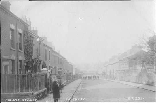
The photographs of Lord Street, Mount Street, Allesley Old Road and Craven Street shown in the gallery below were taken by Ernest Ratledge who photographed several hundred streets in Coventry and Warwickshire around 1900. The pictures were sold as Post Cards and are now known as RP’s or Real Photographs. All were numbered and many have never been found. These copies are of rare pictures and came by email from Vancouver.
In the summer of 1970 the City Council called a meeting of local people in the Church Hall that stood on the large bomb site now occupied by numbers 71 to 99 Craven Street. It was a hot summer night and the people filled and surrounded the building and hung in numbers through the windows. Councilor McLatchie came to tell the people that the council was to compulsorily purchase all the five streets and demolish them. It was then going to build six blocks of flats identical to the ones that had just been constructed in Hillfields. There was uproar. The good councillor went away with his tail between his legs. The plan was abandoned and the area was soon given Assisted Area status and then made a Conservation Area. Much money was made available to assist with redevelopment of private properties and nearly every house benefited – although some damage was done to the overall Victorian characteristics of many houses. Without that assistance many of the houses would have fallen down or become uninhabitable.
Book about Earlsdon and Chapelfields
Coventry Society Members David Fry and his fellow member of the Heart of England Postcard Club, Albert Smith, have published the latest book in their series “The Coventry We Have Lost”. This book highlights the history of the suburbs of Earlsdon and Chapelfields. Unlike previous books, which have concentrated on historic postcards, the current book includes a lot of new research about the two suburbs as well as historic maps and photographs.
The book recounts the history of both suburbs from first plans through to recent years and is a fascinating account of an important part of Coventry’s history. The book is published by Simanda Press in Berkeswell and retails for £8.95 but Coventry Society members are offered a discount if the book is purchased at society meetings.